MSC’s (MicroSave Consulting) digital financial capability (DFC) framework offers a practical approach to designing financial capability policies, programs, and digital solutions. Its five design principles seek to understand target segments, create innovative content, balance delivery channels, coordinate stakeholders, and embed impact-oriented monitoring and evaluation. This framework shows how governments, regulators, and financial service providers can move beyond awareness campaigns to achieve measurable behavior change, safer digital financial use, and stronger consumer protection.
Roadmap to the HPFD Gender Budget Statement 2027–28 Based on Field Diagnostics
Gender-responsive budgeting (GRB) is a key public financial management tool that helps governments integrate gender considerations into planning, budgeting, and resource allocation. India has institutionalized GRB through gender budget statements and supporting policy frameworks. However, many line departments still face challenges that limit implementation due to gaps in institutional systems, administrative data, and reporting mechanisms.
Under the GIZ-supported Strengthening Gender Responsive Forest Ecosystems Management and Agroforestry in India (G-VAN) project, MSC worked with the Himachal Pradesh Forest Department (HPFD) to strengthen its institutional readiness for GRB. The engagement included reviews of departmental schemes and budgets, field diagnostics, assessments of institutional mechanisms and administrative data systems, and consultations with key government stakeholders.
This report presents a practical roadmap to prepare HPFD’s gender budget statement and institutionalize GRB within the department. It identifies implementation gaps, recommends measures to strengthen gender-disaggregated data and institutional processes, and shows how the department can embed GRB across the budget cycle, from planning and resource allocation to implementation, monitoring, and reporting.
As Digitalization Grows, Will Indonesia’s Agent Networks Survive?
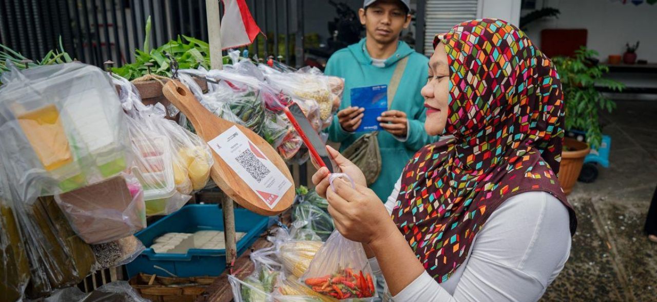
Indonesia is Southeast Asia’s largest digital economy, poised to reach $180 to $340 billion by 2030—by all measures a success story of rapid digital growth. Yet, even as digital transactions surge, Indonesia’s vast informal sector holds on to cash as a central aspect of daily life. Despite the expansion of digital payments, cash in circulation has more than doubled over the past decade to reach approximately $65 billion as of July 2025.
Agents move between the digital and cash economies
At the heart of this coexistence are millions of local agents who make the digital economy work for everyone. Many of them are small business owners who operate from kiosks and local shops called warungs, serving as trusted financial intermediaries that connect communities to banks, payments and other digital products that would otherwise remain out of reach.
As the number of bank branches and ATMs in the country has declined by 25% over the past five years, the number of agents has grown by about 40% annually over the past decade, according to MSC estimates. By 2025, there were more than 2 million registered agents nationwide. While only about one-third of agents remain consistently active, they form a cornerstone of Indonesia’s financial inclusion efforts, serving as the primary channel for FSPs to reach last-mile communities.
Global Findex 2025 data shows that only 30% of Indonesian adults conduct payments independently through self-service channels, such as mobile applications, cards or online platforms, indicating that most people still depend on assisted channels for financial transactions. This continued reliance is reflected in agents’ growing activity, as transaction values continue to increase. Between 2017 and 2023, cash-out transactions rose by 43% and the average transaction volume through agents grew five-fold.
However, as Indonesia’s digital economy grows, individual access to digital channels continues to deepen. Cellphones now reach 68% of the population, and 72% have internet access. Cashless transactions, particularly through Indonesia’s interoperable QR code payment system (QRIS), have been growing at a rate of more than 150% year-on-year. As more people begin to transact independently through mobile and internet banking, a critical question emerges: will agents remain relevant?
How are agents faring in other digital economies?
Globally, digital growth has yet to replace cash, and agents keep the two worlds connected. We see this even in the world’s largest and fastest-growing digital payment ecosystems, such as India and Kenya.
In Kenya, one of the global pioneers of mobile money, cash in circulation continued to climb by $2.6 billion in 2024, a 5.6% increase from the previous year. Meanwhile, agents facilitated mobile money transactions worth $67.3 billion in 2024, nearly double the level recorded in 2019.
In India, the Unified Payments Interface (UPI) – a real-time platform that enables instant fund transfers between bank accounts – has driven a surge in digital payments. UPI transaction volumes increased tenfold in just four years, from 12.5 billion in 2020 to 131 billion in 2024, to account for nearly 80% of all digital payments. At the same time, cash in circulation has more than doubled from $200 billion in November 2016 to reach $418 billion by September 2024, with SBI, India’s largest bank, channeling approximately 3.2 million transactions per day through its agent network.
These examples reveal that even in highly digitalized markets, assisted channels remain essential, suggesting that digital and agent ecosystems will coexist for years to come.
Agents in Indonesia adapt to a dual cash-digital system
Indonesia mirrors this global reality. The strength of its agent model lies in its adaptability to a dual cash-digital system. What began as a simple cash-in, cash-out function has gradually expanded in scope. While not all agents can offer advanced services, many have started to diversify and now sell digital products, offer loans and microinsurance, facilitate QRIS payments, and even serve as delivery or return points for e-commerce.
Traditionally, agents have been vital to enable government-to-person (G2P) transfers and ensure cash reaches low-income households efficiently. Building on this foundation, many agents are now becoming the frontline for financial service providers (FSPs) to deliver more specialized financial products, such as microloans, savings, and climate-risk insurance, helping strengthen rural economies and household resilience.
Agents’ adaptability has built both structural and economic resilience. Agents are not competing with Indonesia’s rapid digitalization; they are powering it. Rather than being displaced by fintechs and mobile banking apps, they form the human infrastructure that makes digital services accessible and trustworthy, especially in areas where cash use is prevalent and digital literacy is low.
Agents remain the bridge between digital systems and communities
The shift toward digital finance in Indonesia is well underway, but agents will remain the critical bridge that connects digital systems to communities. As the ecosystem matures, stakeholders in the ecosystem should now shift their focus from expanding agent coverage to strengthening their capabilities, which would enable them to manage more complex, higher-value transactions and provide greater value to customers.
Providers can support this evolution if they invest in advanced training, streamlined business processes, and data-driven, AI-enabled, tools for effective agent management. Even as technology transforms financial services, the human presence and local trust that agents bring will remain essential to ensuring that Indonesia’s digital finance is both inclusive and scalable. The future of finance is digital, anchored by the agents and their customers who make it work.
This was first published on 28th January 2026 by FinDev Gateway.
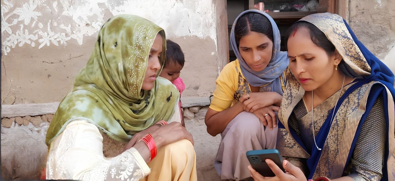
What PMJDY beneficiaries are really telling us beyond access
The room held a quiet anticipation on a June morning in 2026. The Pradhan Mantri Jan Dhan Yojana (PMJDY) beneficiaries sat together, some glancing toward the door. They were waiting to meet someone they had never imagined they would encounter in person: a globally respected advocate for financial health.
Her Majesty Queen Máxima of the Netherlands, the UN Secretary-General’s Special Advocate for Financial Health (UNSGSA), had come to India to engage directly with beneficiaries of the Pradhan Mantri Jan Dhan Yojana (PMJDY). During the interaction, she sought to understand their experiences with formal financial services, including the challenges they face, their awareness and use of PMJDY-linked benefits, their ability to prepare for and manage financial emergencies, the financial shocks they commonly encounter, and the role that trusted banking touchpoints play in supporting their financial wellbeing.
India has opened more than 560 million bank accounts under the PMJDY. It stands as one of the most ambitious financial inclusion drives in the world.
Spend a little time with account holders, and the conversation quickly moves beyond account numbers. People talk aboutthe impact of emergencies on their finances They wonder whether insurance would really support them when it matters. Many say that saving feels harder than borrowing. Almost every group mentions one familiar figure in their community, the business correspondent (BC), who they simply call “our bank.”
These everyday realities shift the focus from financial access to financial health. They may shape the next phase of India’s financial inclusion journey.
The session: Bringing beneficiary voices into a global conversation
On 23rd June 2026, MSC (MicroSave Consulting) led a focus group discussion (FGD) with PMJDY beneficiaries during Her Majesty Queen Máxima’s UN-visit to India. She spoke directly with participants using real-time translation. The exchange felt rare and direct. It created space for honest voices from the ground to meet global advocacy. As the beneficiaries shared their stories, the conversation offered valuable insights into how access to formal financial services can strengthen resilience, improve financial security, and enhance everyday lives.
The findings are both encouraging and sobering. PMJDY has changed lives in visible ways. Yet, beneficiaries are clear that opening a bank account is only the first step.
A major takeaway from the session was that people’s understanding of financial products grows primarily through experience rather than education or outreach. A medical emergency increased awareness about insurance benefits. A financial shock prompted the use of the overdraft facility. Digital payments became important when they addressed an immediate and practical need.
This is an important signal for program design. Financial literacy efforts that are disconnected from lived experience may have a limited impact. Knowledge and action, it seems, often develops when relevance exists.
The insurance gap: Small amounts and big consequences
The PMJDY’s social insurance schemes cover life and accident risks and carry modest annual premiums, by design. Yet, participants described a recurring difficulty. They could not maintain sufficient account balances when those premiums fall due.
A participant noted, “The amount for the premium is small, but sometimes there is no money in the account when it is deducted.”
The issue is not a lack of willingness to pay. The problem is the mismatch between the timing of deductions and the availability of funds. It is a direct result of irregular, seasonal, and informal incomes that define the lives of many PMJDY beneficiaries. Insurance continuity, therefore, might be just as important as insurance coverage itself.
The savings gap: Easier to borrow than to save
Participants noted a shift from moneylenders to formal credit, particularly banks and self-help groups (SHGs). SHG loans have become a trusted and accessible source of emergency funding for health costs, household needs, and short-term cash needs. This is a notable achievement, but regular savings remained out of reach.
Another participant shared, “If there is a need, we can arrange a loan. Saving every month is more difficult.”
Access to credit and the ability to build financial resilience do not always develop together. A household that can borrow during a crisis is better positioned than one that cannot. However, a household that can save and handle a shock without taking on debt is in a fundamentally different position. The savings gap remains a significant and often overlooked challenge in financial inclusion and financial health.
The BC continues to be the face of the financial system
Perhaps the most striking theme in the discussion was the role of the BC. For many participants, the BC was not a service channel but represented the entire financial system, as several participants referred to their BC simply as “our bank.”
Beneficiaries reported how this single human touchpoint helped them open accounts, conduct transactions, understand products, access government benefits, and resolve issues.
As financial services become more digital, a common assumption holds that human intermediaries will become less important. However, the evidence from this session suggests otherwise. For many beneficiaries, trust still depends on personal relationships, local presence, and access to help when issues arise. In a growing digital ecosystem, the BC’s role might actually matter more.
The questions beneficiaries ask
Throughout the discussion, beneficiaries did not question whether they could access a bank account, as the question had already been answered. Instead, they asked more difficult questions, such as:
“Am I saving enough to handle an emergency?”
“Will my insurance still be there when I need it?”
“Can I use digital services confidently without fear of making a mistake?”
“Is there someone I can rely on if something goes wrong?”
“Can my household handle a financial shock?”
These questions reflect concerns about financial resilience, confidence, and well-being, as account ownership data alone cannot answer them.
The next chapter in financial health
India’s journey toward financial inclusion has effectively answered the key question of whether people can access formal financial services. The PMJDY’s response has been a clear yes.
When the discussion ended, the beneficiaries had not asked for more bank accounts. UNSGSA Queen Máxima came to listen, and what she heard was unfinished progress. India’s population, which had crossed the threshold of access, grapples with quieter questions of financial resilience. The beneficiaries did not need anyone to explain financial health. They described it themselves, in the gap between a premium due date and an empty account, and in the comfort of a BC. They offered a clearer map of where India’s financial inclusion journey goes next.
This blog is based on insights from FGD with PMJDY beneficiaries, convened by MSC during Her Majesty Queen Máxima of the Netherlands’ visit as UNSGSA to India. She was visiting in her capacity as the United Nations Secretary-General’s Special Advocate for Financial Health. MSC has been working on financial inclusion across emerging markets for more than 27 years.
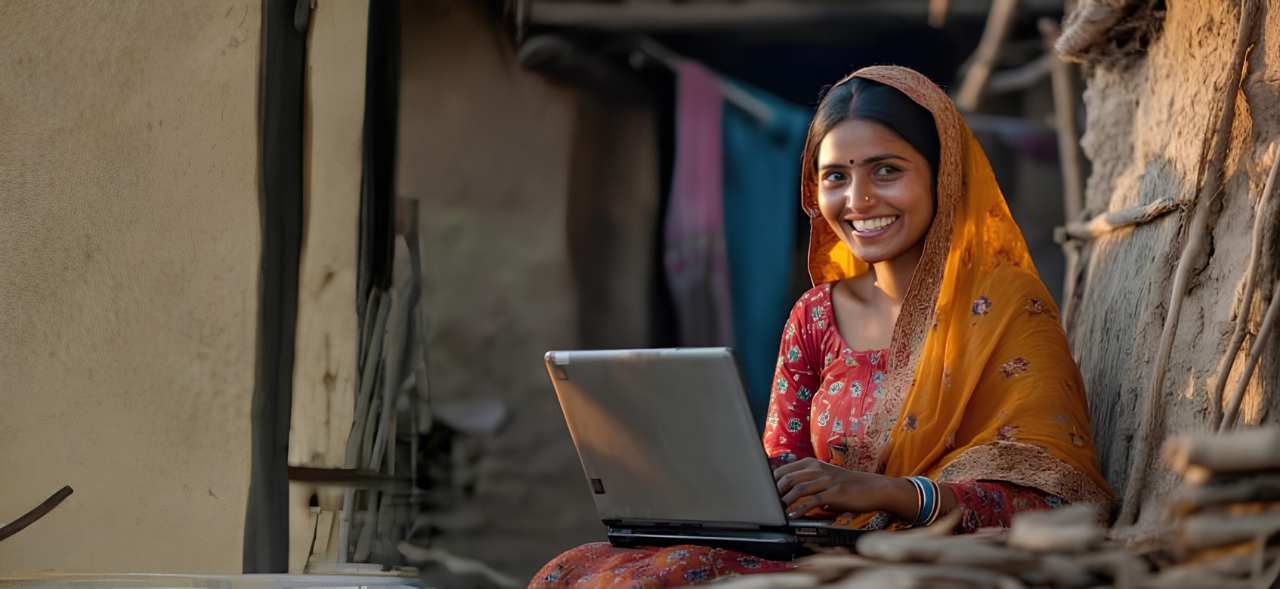
Why Bihar and Uttar Pradesh are emerging as India’s new women enterprise credit hubs
Between 60% and 70% of rural women nano-entrepreneurs now accept digital payments. This suggests that formal financial participation is no longer limited to a small group of borrowers, but is spreading across a broader base of women-led economic activity.
For years, finance for women in India followed a familiar map. Southern states built some of the country’s strongest ecosystems for women’s participation in formal finance through self-help groups, cooperative lending, and deeper integration with the banking system. As a result, discussions on women’s financial inclusion often looked south for examples of what worked. The map no longer looks the same.
The fastest growth in women’s enterprise credit now comes from Bihar and Uttar Pradesh. This development is significant, as it signals a rapid expansion of women-led enterprise activity. For years, the focus of women’s finance was access. While that challenge has not disappeared, it looks different today. Women’s credit penetration has risen from 19% in 2017 to 36% in 2025, and India now has 16 crore credit-active women borrowers. The latest data points to a new question. Where will the next phase of enterprise growth come from?
The numbers are difficult to ignore. Between 2022 and 2025, lending to women for business purposes grew the fastest in Bihar and Uttar Pradesh, with a CAGR of 59% and 42%, respectively, while the national commercial credit growth stood at 17%. These figures challenge long-held assumptions about where growth can likely come from.
Discussions on Bihar and Uttar Pradesh traditionally focused on bringing more women into the formal financial system. Today, they are among the fastest-growing markets for women’s enterprise lending. The change did not happen because Bihar and Uttar Pradesh replicated the southern model of financial inclusion. It happened because the barriers to formal finance changed.
For decades, several small businesses, especially women-owned, operated largely in cash and outside formal recordkeeping systems. A tailor, food vendor, or shop owner could earn a steady income and support their household without providing the documents that banks typically relied on to assess creditworthiness.
Without formal business records, credit histories, or significant assets in their own names, lenders struggled to evaluate borrowers. Banks, therefore, relied heavily on branch networks, field verification, and long-standing borrower relationships to assess risk.
Digital public infrastructure (DPI) fundamentally altered many of those constraints. Digital payments, Aadhaar-enabled onboarding, smartphones, and retail lending products made it easier for first-time borrowers to establish a financial footprint.
Transaction histories opened new ways for lenders to assess borrowers who previously remained outside formal finance. As a result, participation could expand without waiting for decades of branch-led institution-building.
The impact is visible in the profile of new borrowers. Gold loans remain the most popular entry-level product gateways into formal finance. These accounted for 23% of new-to-credit women borrowers in 2025, up from 16% in 2022. During the same period, women’s share among new-to-credit retail borrowers rose from 28% to 38%.
These trends suggest that many women now enter the formal financial system through smaller, more accessible credit products before they progress to larger borrowing relationships. As those entry points expanded, participation grew in markets that historically had lower levels of formal credit penetration.
Between 60% and 70% of rural women nano-entrepreneurs now accept digital payments. This suggests that formal financial participation is no longer limited to a small group of borrowers, but is spreading across a broader base of women-led economic activity. That success creates a new challenge: Rapid growth does not automatically translate into deeper financial participation. Nationally, 19% of active microfinance borrowers also hold an individual retail or commercial loan. Tamil Nadu stands at 27%, while Bihar and Uttar Pradesh remain below 12%.
The gap highlights an important distinction. Access brings borrowers into the formal financial system. The ability to graduate from first-time borrowing to larger productive credit determines whether they can move into larger credit products, expand businesses, and build assets over time.
This matters because the fastest-growing markets for women’s enterprise credit are not always the markets with the strongest pathways for credit progression. If the first phase of financial inclusion sought to bring women into the system, the next phase must help them advance within it.
The broader lesson is that the geography of women’s enterprise growth map is changing. The South remains home to some of India’s most mature financial ecosystems. Yet the fastest expansion in women’s enterprise credit is occurring in Bihar and Uttar Pradesh. Together, they account for 12% of India’s credit-active women business borrowers. The institutions that support that growth should evolve as quickly as the map itself.
India’s women’s credit story is entering a new phase. It is broader, deeper, and increasingly geography-agnostic. The South built the foundation, but states like Bihar and Uttar Pradesh, once considered laggards, are scaling it. The institutions must recognize this shift early and invest where the next generation of women borrowers, savers, and entrepreneurs is already emerging.
This was first published on 20th July 2026 by Financial Express.